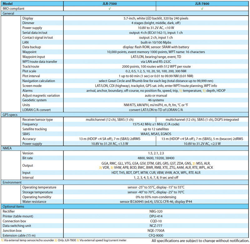
Products

JLR7500-7800
The new JLR-7500/JLR-7800 (D)GPS navigator always locate your position accurately and gives you a wide range of possibilities – integrated with the latest technologies – that will enhance your operational performance.
With some of the features being: 5.7″ high visibility display, 3D highway display and smart route calculations. Added display control feature like sharpness and contrast compared to previous versions will make reading out from the display much easier and comfortable.
Many display modes are readily available and selectable from the menu, such as navigation, CDI, 3D highway, track plotting and service and information screens.
Features
The new JLR-7500/JLR-7800 (D)GPS navigator will locate your position accurately and gives you a wide range of possibilities – integrated with the latest technologies – that will enhance your operational performance.
3D highway
One of the new display modes is the 3D highway, which allows you to intuitively view the location of the next waypoint. This 3D guidance is particularly valuable to follow a real-time chain of waypoints along a planned route.
Smart route calculation
The new (D)GPS navigator allows you to plan long distance routes highly effective. It is possible to set Rhumb lines (RL) for short legs, while Great Circle (GC) can be set for the long distance legs – all possible within the same route. Simply make your selection for each leg to reach your destination effortlessly.
Display modes
All information is displayed on a highly visible 5.7-inch LCD display, featuring added sharpness and contrast compared to the previous version. Many display modes are readily available and selectable from the menu, such as navigation, CDI, highway, track plotting and service and information screens. The display has four dim modes, allowing adjusting at your own convenience.
Unified design
The new display design allows you to carry out all operations simply by using the unified keyboard layout. The keyboard is solid and responsive, which allows for precise operation. The keys are also back-lit, making it easy to operate in low-light settings on the bridge.
Simple operation
The compact design of the JLR-7500/JLR-7800 incorporates a new intuitive interface, providing enhanced ergonomics and user friendliness. The logic of the controls and excellent on-screen menus will greatly shorten most users’ learning period.
Key in data
With the new (D)GPS navigator, entering data is just as simple as creating a (SMS) text message on your phone. The consistency in the keyboard layout allows entering waypoint data fast and in a natural way.
Satellite integrity check
The newly developed sensors include RAIM, which is to access the integrity of GPS signals. If multiple satellite signals are picked up, this system will check if the position fix is consistent with the computed position, assuring higher reliability than conventional methods.
Port flexibility
The (D)GPS navigator integrates four configurable NMEA ports. This advanced feature will allow you to e.g. have one port configured with the latest NMEA standard, while another port is capable of running a previous version. In this way you can connect older equipment onboard. It also has one in and two contact outputs and LAN, which facilitates route data transfer and/or interswitching.
Easy installation
The display is very compact and can be mounted virtually anywhere, allowing for a flexible installation approach in confined spaces.
The base of the sensor is designed for an easy installation, either on a pole or on an extension mast. The base also includes a slot allowing for easy cable management, significantly reducing installation time.
My memory
Up to 10,000 waypoints can be stored in the internal memory. All waypoints can be named and renamed up to sixteen characters. You can make 100 routes with 512 waypoints per route, which can be entered randomly, and there’s room for 2000 points.
LAN advantage
Via a LAN connection, you can easily connect two displays.
The second display is fully operable and auto synchronizes with the main display, which is directly connected to (D)GPS sensor, allowing e.g. acknowledging alarm or adjusting waypoints/routes at a secondary location on the ship.
You can also set for a dual installation, having two (D)GPS sensors connected to two different displays to simply switch when necessary, assuring you always on.