Products

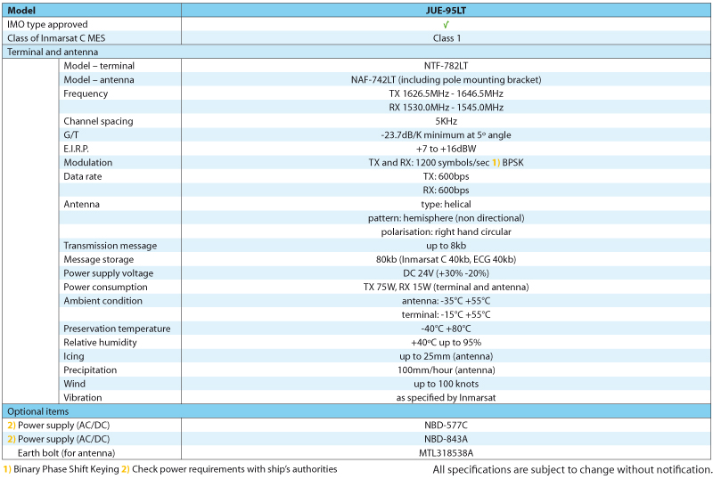
JUE 95 LT
JRC’s new LRIT system will easily and accurately provide all key information
Features
The JUE-95LT is a simple-to-install stand-alone system that will easily and accurately transmit key information to improve the safety of life at sea.
About LRIT
Long Range Identification and Tracking (LRIT) is an IMO required global monitoring system of the ship’s movements. The purpose of LRIT is to increase maritime domain awareness and to improve maritime security.
Background
Ships sailing under the flag of a country that signed up to the International Maritime Organization Safety of Life at Sea (SOLAS) convention must comply with new LRIT requirements from 2009 onwards. From this date, vessels must automatically transmit their identity and position, including date and time, at 6-hourly intervals. Additionally this system must be able to respond to requests from member states and LRIT data centers for immediate position reports and be able to change the time interval between reports to a maximum frequency of every 15 minutes.
Flexible installation approach
The JUE-95LT system has the same cable management philosophy resembling all other Inmarsat products that JRC is offering, allowing for an easy installation as only a single coax cable is used between antenna and terminal. Both are very compact and can be easily installed on any size and type of vessel.
Who’s it for?
The Long-Range Identification and Tracking (LRIT) regulation will apply to the following ship types engaged on international voyages:
- All passenger ships including high speed craft,
- Cargo ships, including high speed craft of 300 gross tonnage and above, and
- Mobile offshore drilling units.
All vessels of 300 gross tonnage and above on international voyage will need to be compliant with LRIT regulations.
Those ships operating exclusively in coastal Sea Area A1 and fitted with an Automatic Identification System will be exempt, while ships operating in near-coastal Sea Area A2 not fitted with Inmarsat C GMDSS will be required to fit a compliant terminal. Ships operating in polar Sea Area A4 above 70 degrees latitude will require a non-Inmarsat terminal that operates in conjunction with a low-earth orbit Communication Service Provider (CSP) approved by the Flag in conjunction with its appointed Application Service Provider (ASP).
A phased approach to the implementation of the regulation will allow for compliance not later than the first radio survey after 31 December 2008 or in the case of ships operating in Sea Area A4 not later than the first radio survey after 1 July 2009.
The terminal must be capable of being configured to transmit the following minimum information set in an Automatic Position Report (APR):
- The identity of the ship
- The position of the ship, and
- The date and time of the position.
In addition, the terminal must be able to respond to polling for an on-demand position report and be able immediately to respond to instructions to modify the APR interval to a frequency of a maximum of one every 15 minutes. APR’s will be transmitted as a minimum 4 times per day to a National Data Centre (NDC), a Cooperative Data Centre (CDC), or a Regional Data Centre (RDC) nominated by the Flag (collectively “DC’s”).